3rd June 2025 (updated monthly, or when track conditions change).
THE SIMPSON IS OPEN ALL THE WAY TO BIRDSVILLE VIA THE BYPASS TRACK AT EYRE CREEK. SEE DETAILS IN THE SIMPSON DESERT TRACK CONDITIONS BELOW.
WHEN DRIVING ON FLOODED ROADS, STAY IN THE CENTRE OF THE ROAD UNLESS THERE IS A WELL MARKED AND DRY BYPASS.
THE CENTRE OF THE ROAD IS THE FIRMEST. TRYING TO GET ONTO SEEMINGLY DRY EDGES WILL USUALLY GET YOU INTO TROUBLE.
Information contained in this notice is a general view of what to expect, track conditions change due to weather or deterioration by vehicle numbers. The Simpson becomes rougher as the year goes on due to vehicles with incorrect tyre pressure and/or towing trailers.
Use UHF repeaters, (duplex) to contact locals ie; Pink Roadhouse ch7 Dup or Mt Dare Hotel Ch 6 (Ch 2 near Dalhousie) or Ch 40 if close to the hotel, when necessary. UHF repeater channels are 1-8 and 31-38 and are there for your safety not for chit-chat. Channel 10 UHF is for use in the Simpson Desert to check for oncoming traffic, choose an unallocated channel for "chit chat".
Really do use caution and reduced tyre pressures will help if it's muddy. Sand pressures are best if it's really wet.
Drive carefully on all Outback roads even if they have been graded.
NOTE:
Drop your tyre pressure by at least 20% (from highway pressure) for travel on these outback tracks (or reduce pressure until they bulge a little), the risk of tyre damage is greatly reduced, you will have a smoother ride and better traction. As a guide - below 30psi on the dirt/gravel and below 20psi in the sand. N.B. Keep speeds down on low sand tyre pressures.
Please leave ALL gates as you found them. In a convoy make this is clear to the last vehicle through the gate. Slow down and move over for oncoming traffic or when being overtaken, in the interest of safety and to avoid a broken windscreen.
Trailers that are not purpose built for tough off road conditions are definitely NOT recommended. Leave the 6'x4' garden trailer home and hire a decent one! Check out www.mtdare.com.au vehicle preparation for more tips. Otherwise be prepared to visit our workshop for repairs.
DRIVING TIP
Slow down in rutted sections (caused by a vehicle’s wheels after rain), this is the cause of many roll overs. Avoid driving at night as animals, sharp corners and road damage are hard to see. Slow down when driving through puddles and creeks (less than 20 km/hr). Excess speed is of no benefit and can cause muddy water to enter the air intake of the engine and the alternator resulting costly repairs.
ROAD CONDITIONS
IF THE NT ROAD REPORT DIFFERS FROM OURS PLEASE CALL US FOR CLARIFICATION
KULGERA – FINKE
Well graded road, but still watch your speed. Watch out for dips and some washouts at flood ways and creeks.
(2 hr 150 km)
LAMBERT CENTRE
The 12km drive is slow, a bit sandy and has many washouts; allow at least an hour to return to the Kulgera – Finke rd. There’s a flag pole that looks like it belongs in Canberra and marks the geographical centre of Aus, and a long drop toilet, this should stop the toilet paper confetti from decorating the bush. This track is not maintained and is passable by 4x4 only.
1 hr, 24 km
ALICE – FINKE (OLD GHAN TRACK)
The sandy sections after Bundooma siding will have some soft sections and there will be corrugations developing.
Slow and undulating whoops along the old road now the “Finke Desert Race Track”, this section is not maintained.
Beware of washouts along the railway line/road; watch out at creeks and dips. Beware of oncoming traffic; beware of abandoned cars, severe washouts & rutting. 4x4 is necessary.
Fuel and other supplies are available at Maryvale Station Store.
4 hr, 220 km
ALICE – OLD ANDADO
Road is in good condition.
Now also known as the Binns track. An easy run from the Airport to Alambie Station on a well graded road. The drive through the Rodinga Range is quite spectacular. This is definitely a worthwhile alternative way to go south (or north) and the Mac Clark reserve is only a short detour to see the Waddy trees, (Australia's rarest tree). Watch out for possible bulldust sections or washouts, high clearance 4x4 recommended. Beware of Bulldust.
Add 1 hr if visiting the Waddy trees.
OLD ANDADO – MT DARE (START OF THE BINNS TRACK)
Molly Clark has passed away, but you are still welcome to have a look around or to camp at Old Andado. The old homestead is like a living museum, so please treat it with respect and leave all items as they were found. Please respect the hard work that Molly has put into preserving a piece of Outback cattle station history for all of us to enjoy. Look after the place and don't leave any rubbish, there is no rubbish disposal there. If you are interested in caretaking, look at the website.
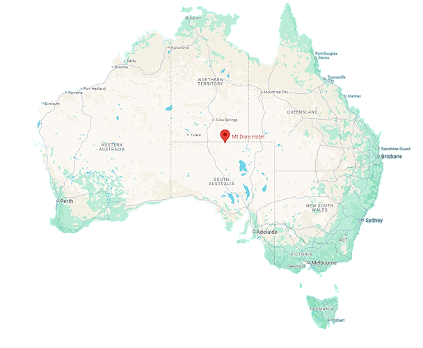
Mt Dare is the start of the Old Andado track that is now also known as the Binns track, this is one of the Outback’s picturesque drives through the Finke River flood out and the Binns Track continues past Alice Springs to meander through the Territory and finish at Timber Creek, a great 2 week journey.
Watch out for cattle. Some track re-alignment has been done allowing more room for larger vehicles and caravans, so ignore the GPS and follow the track. Beware at cattle yards as the track can be hard to see. There is extensive bulldust throughout the Finke floodout, take care. There are many gates, leave them as you find them, this section is not maintained, high clearance 4x4 is essential. Beware of bulldust.
2 hr, 100 km
FINKE – MT DARE
There are some water patches which can be easily navigated around.
Watch out for whoa buoys (raised mounds to deter water from flowing along the track) at Charlotte waters. Slow down for oncoming traffic. There are no services or fuel available for the public at New Crown Station. Watch out for cattle. UHF repeater channel 6 covers this area, use this only to contact the Pub.
1 1/2 hr, 100 km
Finke is an alcohol free Aboriginal community; there is no campground or toilets and no services for travellers except for the Finke community store which has limited hours.
Mt Dare Hotel has fuel and is licensed. Take away alcohol is available. Fuel & supplies are also available at Maryvale Stn Store.
MT DARE – DALHOUSIE SPRINGS
The Parks tracks are graded generally in June. Drive to conditions.
There are no shops or fuel available at Dalhousie Springs; but there are cold showers and two dumps for your rubbish. Dalhousie Pass or Desert Parks Pass are needed for this area, you can purchase both passes at the Mt Dare Hotel or online. UHF repeater channel 6 & 2 covers some of this area, use this only to contact the Pub.
1 1/2 hr 70 km
FIREWOOD COLLECTION OR WOOD FIRES ARE NO LONGER PERMITTED IN WITJIRA NATIONAL PARK AT ALL. (This does not include the Simpson Desert Conservation Park or Regional Reserves.) Camp fires are still permitted at Mt Dare, collect fire wood before entering the Park and arriving at Mt Dare or you can buy firewood from Mt Dare at the cost of $35.00 per bag.
MT DARE – HAMILTON STATION (Via Eringa Waterhole)
HAMILTON STATION - OODNADATTA
Beware of cattle & on-coming traffic traveling over the Sand hills just south of Hamilton Homestead. Eringa Waterhole is a nice spot for a rest, but please take all your rubbish with you when you leave. Look after this area as it is a privilege to use it. Watch out for cattle. This was Kidman's first ever property. No pass needed for this track. UHF repeater channel 6 covers some of this area, use this only to contact the Pub.
4 hr, 250 km
DALHOUSIE – HAMILTON Stn (via Pedirka ruins)
BLOODS CREEK WINDMILL to DALHOUSIE TRACK (via Ferderal ruins)
OPEN
THE DESERT LOOP(S)
IF RAIN OR A FLOODED EYRE CREEK MAKE A COMPLETE DESERT CROSSING IMPOSSIBLE, YOU CAN STILL HAVE THE FULL DESERT EXPERIENCE BY COMPLETING ONE OF A FEW LOOPS STARTING AND FINISHING AT MT DARE.
FRENCH LINE/ERABEENA/RIG RD This one will allow you to test yourself on the French Line before dropping down the Erabeena Track (about half way across) to the Rig Rd, passing the Lone Gum and heading back to Mt Dare on a slightly easier track with very different and interesting country.
FRENCH LINE/ERABEENA/WAA LINE
Very similar to the first loop but returning on the WAA Line which is almost as challenging as the French Line.
FRENCH LINE/KNOLLS TRACK/RIG RD
If it is not too wet, this loop takes you past the Approdinna Knolls down to the WAA Line where you can drop down to the Rig Rd for the return trip.
THE MADIGAN TRACK EXITING THE DESERT TO THE NORTH VIA JERVOIS TO THE PLENTY HIGHWAY
This alternative requires a CLC permit and depends on track conditions on the Hay River Track
You can make your own combination of tracks to suit the conditions and preference.
Dalhousie Springs & the Witjira National Parks
DALHOUSIE SPRINGS – PURNI BORE
ROCKS ROAD – OODNADATTA CLOSED
FRENCH LINE, PURNI – POEPPEL CORNER
OPEN
THERE IS A DETOUR TRACK BEFORE LAKE POEPPEL FROM THE WEST WHICH WILL TAKE YOU TO THE BYPASS CROSSING, APPROX 40 KM NORTH OF THE QAA LINE. THE CROSSING HAS A STONY BASE BUT CHECK THE DEPTH BEFORE CROSSING.
ALWAYS CHECK CLAYPANS BEFORE CROSSING. TAKE THE DETOUR IF IN DOUBT, PARTICULARLY IF YOU ARE A SOLO VEHICLE
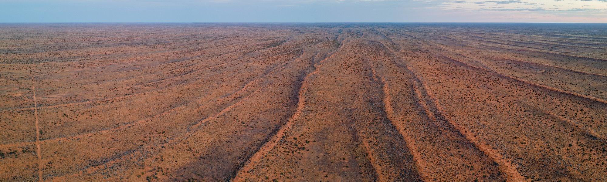
The French Line is the most demanding track in the Simpson, it normally has very soft sand and is slow going all the way (15–20 km/h), however the cooler weather and less traffic has the sand in the best condition it has been in for years. Reduced tyre pressures are still essential.
Scalloping is contributed to mostly by vehicles with incorrect tyre pressure along with towing trailers.Trying to drive the Simpson in 2WD is not being clever, it is damaging the track. Trailers of any kind are NOT recommended on the French Line (use the Rig rd). It’s very important to CHECK YOUR TYRE PRESSURE (15 – 20 psi). This is the most demanding and difficult track in the Simpson.West to East is a bit easier though. DEFINITELY USE 4x4.
16 hr, 195 km
RIG ROAD & K1, PURNI – POEPPEL
CLOSED DUE TO WATER ON K1
This track is the least demanding but has been deteriorating over the years and becoming quite rough; with many sand drifts and with its clay capping slowly breaking up, travel is becoming more difficult. It is still easier than the French Line or WAA line. Care must be taken when cresting sand dunes; this track has corrugations, deep washouts & rutting. Sand dunes between the Knolls track and the K-1 Line are more difficult to cross especially from the west, single vehicle travel or trailers are not recommended in this section. The K-1 line may be difficult to navigate along as it is seldom used.
16 hr, 399 km
WARBURTON TRACK
CLOSED. DUE TO FLOODING
YOU WILL NEED TO CARRY ENOUGH FUEL TO GET FROM MT DARE TO MUNGERANIE. THE LONGEST ROUTE IS VIA THE FRENCH LINE AND THAT IS ABOUT 640 KM. IT IS A BIT SHORTER USING THE WAA LINE OR THE RIG RD.
Call the Mungerannie Hotel for more info 08 8675 8317.
PURNI – POEPPEL CORNER VIA WAA LINE & KNOLLS TRACK,
SEE THE ADVICE FOR PURNI TO POEPPEL CNR
There may be some soft spots at Lake Poeppel. Use the chicken track if you are unsure.
This has the same soft and sandy conditions as the French Line but with smaller dunes and very picturesque after rain. While in this area take a look at the Lone Gum and the Knolls; this is a scenic but fragile part of the Simpson, please stay on the track. USE 4x4.
16 hr, 237 km
QAA LINE, POEPPEL CORNER – BIRDSVILLE
OPEN - THE BYPASS TRACK IS OPEN
Travel is much like the French Line only the sand dunes get bigger and further apart, with the biggest dune being BIG RED, it is very rough and corrugated on the western approaches. There is a detour around this giant dune if you can’t get over it, (don’t kill yourself trying) you can also cross over at Little Red only 2km further south. Take care at salt lakes as they can be a bit wet; drive in existing wheel tracks only. USE 4x4.
6 ½ hr, 170 km
MADIGAN AND HAY RIVER TRACKS - WEST TO EAST CROSSING ONLY
PERMIT REQUIRED
CONTACT ADRIA DOWNS FOR PERMISSION FOR ACCESS AND CONDITIONS EAST OF THE HAY RIVER TRACK.
For further information go the the Central Land Council's website https://www.clc.org.au/articles/info/application-for-an-entry-permit
COLSON TRACK SOUTH OF MADIGAN LINE
OPEN
ADVICE ON ROADSIDE ASSISTANCE
Be aware that the Roadside Assistance offered by most Automobile clubs and car retailers WILL NOT cover you in the Simpson Desert. Once you are back on made roads you are covered again. Some companies will cover recoveries in the desert. Club 4x4 is one. There may be others. It is worth investigating before your trip.
WE STRONGLY ADVISE AGAINST TOWING CAMPER TRAILERS ACROSS THE DESERT. TOWED TRAILERS WILL ALWAYS CONTRIBUTE TO WHEEL SPIN AND CAUSE DAMAGE TO THE DUNES. TOWING PUTS A LOT OF STRAIN ON THE TOW VEHICLE AND CAN RESULT IN DAMAGE TO SUSPENSION COMPONENTS AND DRIVE TRAINS IN THE CAR . THERE ARE ALSO HUGE PRESSURES PUT ON THE TRAILERS. WE HAVE HAD TO DO A NUMBER OF RECOVERIES OF CARS TOWING TRAILERS WITH CLUTCH, AND SUSPENSION PROBLEMS AS WELL AS BROKEN TRAILER AXLES AND 'A' FRAMES.
THIS CAN BE AN EXPENSIVE EXERCISE.
WE ARE HAPPY FOR YOU TO LEAVE YOUR CAMPER OR CARAVAN AT MT DARE (FREE OF CHARGE) TO DO A DOUBLE CROSSING
NOTE:
The Simpson Desert is a dangerous place if you are not well prepared. It is recommended to have a Sat-phone or HF radio as well as a UHF, extra water, fuel and supplies, a sand flag is now compulsory.
Towing trailers across the Simpson is strongly discouraged, it's very difficult, it's hard on the vehicle and trailer resulting in frequent bogging. Exceptional skill and a powerful vehicle with lower tyre pressures are necessary, possibly as low as 14PSI. Having to dig or be towed out of a bog is a certainty, testing friendships with the burden. Some people still persist with towing their trailer and the result can be costly if it goes wrong, take this advice and leave the trailer at Birdsville or Mt Dare if you are not very experienced.
Towing a camper trailer with any dual-cab Ute can have dire consequences resulting a bent, or cracked chassis.
You should allow at least 3-4 full days to cross the Simpson; the desert has no respect for itineraries so plan for the unexpected. Make sure you have a Desert Parks Pass, a flag that can be seen, at least 2.5 m high above the bull bar and a UHF radio on channel 10. Sat Phones can be hired from or dropped off at the Mt Dare Hotel and the Birdsville info centre. PLEASE TAKE RUBBISH WITH YOU AND BURN ALL TOILET PAPER, so it doesn’t blow around in the wind. It may be necessary to pick up someone else’s rubbish. You can deposit rubbish in the dumps at the Dalhousie Springs or Birdsville.
Desert tracks are not maintained so take care, conditions can change rapidly, especially when it's windy or when there has been rain. CHECK YOUR TYRE PRESSURE we understand that you have a lot of weight but start at 20 psi in the rear & 18 psi in the front, “hot” and reduce further if you have difficulty, maybe as low as 15psi in some cases. You have a 4X4 use it, this is a 4WD track, select 4wd. For advice on how much fuel to take or any other questions about Outback travel just look at the vehicle preparation page, or call, or email Mt Dare Hotel, advice is free, recovery is not.
Go to www.environment.sa.gov.au/parks/visitorinformation/latest/index.htm and click on the link for more information about Desert Parks SA. More info about QLD Parks at http://www.derm.qld.gov.au/parks/simpson-desert/about.html
WEATHER
Still fairly warm through the day (high 30's to low 40's) and will be hotter in the desert.
EVERY EFFORT IS MADE TO ENSURE THE ACCURACY OF THIS INFORMATION BULLETIN, CONDITIONS CAN CHANGE RAPIDLY SO USE COMMON SENSE AND TAKE CARE. Travel times are only a guide, drive according to the conditions at all times.
This Bulletin is prepared by the Mt Dare Hotel, with information gathered from many sources, including tourist feedback, care and common sense should always be used. Further information is available by contacting MT DARE HOTEL:
Enjoy your trip and have a safe one.